Address
9530 Osborne Turnpike
Henrico, VA
Geo Coordinates
37.401666, -77.386347Description
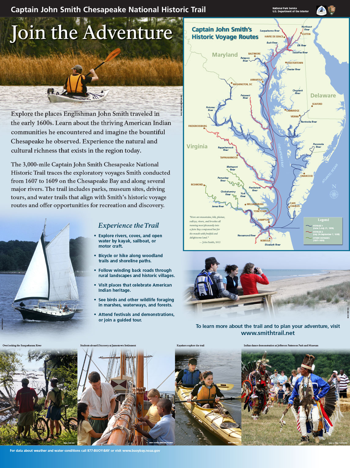
Join the Adventure, Panel 1
Explore the places Englishman John Smith traveled in the early 1600s. Learn about the thriving American Indian communities he encountered and imagine the bountiful Chesapeake he observed. Experience the natural and cultural richness that exists in the region today.
The 3,000-mile Captain John Smith Chesapeake National Historic Trail traces the exploratory voyages Smith conducted from 1607 to 1609 on the Chesapeake Bay and along several major rivers. The trail includes parks, museum sites, driving tours, and water trails that align with Smith’s historic voyage routes and offer opportunities for recreation and discovery.
Experience the Trail
- Explore rivers, coves, and open water by kayak, sailboat, or motor craft.
- Bicycle or hike along woodland trails and shoreline paths.
- Follow winding back roads through rural landscapes and historic villages.
- Visit places that celebrate American Indian heritage.
- See birds and other wildlife foraging in marshes, waterways, and forests.
- Attend festivals and demonstrations, or join a guided tour.
John Smith Explores the Chesapeake, Panel 2
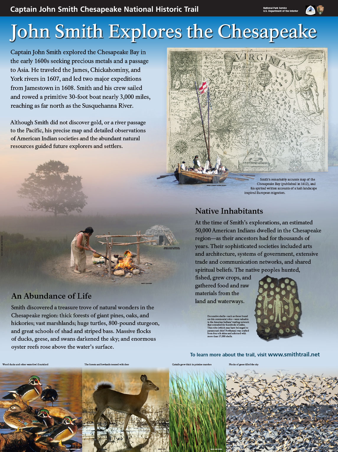
Captain John Smith explored the Chesapeake Bay in the early 1600s seeking precious metals and a passage to Asia. He traveled the James, Chickahominy, and York rivers in 1607, and led two major expeditions from Jamestown in 1608. Smith and his crew sailed and rowed a primitive 30-foot boat nearly 3,000 miles, reaching as far north as the Susquehanna River.
Although Smith did not discover gold, or a river passage to the Pacific, his precise map and detailed observations of American Indian societies and the abundant natural resources guided future explorers and settlers.
Native Inhabitants
At the time of Smith’s explorations, an estimated 50,000 American Indians dwelled in the Chesapeake region—as their ancestors had for thousands of years. Their sophisticated societies included arts and architecture, systems of government, extensive trade and communication networks, and shared spiritual beliefs. The native peoples hunted, fished, grew crops, and gathered food and raw materials from the land and waterways.
An Abundance of Life
Smith discovered a treasure trove of natural wonders in the Chesapeake region: thick forests of giant pines, oaks, and hickories; vast marshlands; huge turtles, 800-pound sturgeon, and great schools of shad and striped bass. Massive flocks of ducks, geese, and swans darkened the sky; and enormous oyster reefs rose above the water’s surface.
Curvy Course, Panel 3
Navigating the curving meanders of the river above Jamestown was tedious for boaters in John Smith’s day. Too difficult to sail, men had to row through long stretches known as the oxbows. Yet the colonists made numerous trips upstream to “discover” the river and
obtain food from the Indians. Smith’s map records more Indian towns above Jamestown than below. The rich soils and aquatic life along the meanders attracted native—and later European—settlements.
Bypassed when man-made channels straightened the course of the river for easier navigation, the oxbows still offer abundant natural resources and views the early explorers might have known.
Explore more of the John Smith Trail at nearby sites along the James River:
- Experience hands-on history at Henricus Historical Park amidst a re-created 17th-century English colony and Arrohateck Indian town.
- Paddle the Lagoon Water Trail at Dutch Gap Conservation Area and see how nature has reclaimed a former industrial site.
- Watch for bald eagles and other species at Presquile National Wildlife Refuge, on an island nearly surrounded by a James River oxbow.