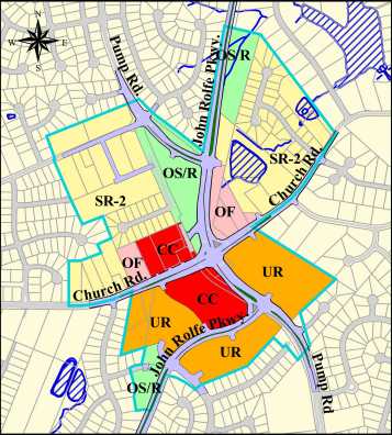
The Henrico County Board of Supervisors approved amendments to the 2010 Land Use Plan for the Church Road and Pump Road Land Use Study Area. The Board of Supervisors also designated the study area a Special Strategy Area in the 2010 Land Use Plan and adopted guidelines to help ensure any new development adheres to the village concept outlined by the study.
The Land Use Plan recommends a wide variety of land uses for the study area. This mix of uses would assist in creating the village concept. The uses are also arranged to buffer existing residential areas from the more intense land use designations. If a parcel lacks the appropriate zoning for a particular use described in this plan, it would have to successfully navigate through the rezoning process in order for that use to occur.

This Plan maintains the Commercial Concentration classification for the service stations/convenience stores at the northwest corner of the Church/Pump intersection. Further west along the north side of Church Road is a small area recommended for Office before a larger transition area of Suburban Residential. All of the Suburban Residential shown in the proposed plan is Suburban Residential 2 (SR-2), which recommends 2.4 to 3.4 net units per acre. The Suburban Residential 2 designation is consistent with the existing single family residential development in the study area. Based on the recommended land uses for this area, off-site improvements to the existing sewer lines may be required in order to provide adequate capacity. The remaining portion of the northwest area is comprised of additional Suburban Residential and Open Space/Recreation (OS/R) uses. This large area of OS/R, as well as the other smaller areas, is a remnant of the land purchased by the County for construction of the John Rolfe Parkway. Due to its large size and central location, this area could be developed as a playground or a park, creating a village square for the community. Any improvements should be passive in nature, and easily accessed by pedestrians.
The area immediately adjacent to the northeast corner of the intersection is recommended for Office development. Between the Office designation and the Chapelwood subdivision is an area of Suburban Residential. There is also an area shown as Open Space/Recreation between the Chapelwood subdivision and the extension of John Rolfe Parkway. This parcel is anticipated to remain in its natural state and act as a buffer between the existing neighborhood and the new road.
The realignment of the Church/Pump intersection will displace the existing Thompson’s Market. In the plan, this is an area recommended for Urban Residential. Urban Residential suggests residential development at 3.4 to 6.8 net units per acre. This designation will allow the properties to develop as age restricted assisted living facilities, town homes or condominiums.
John Rolfe Parkway will divide the land in the southwest quadrant of the new intersection. The area bounded by John Rolfe Parkway, Pump Road, and Church Road is shown as Commercial Concentration on the easternmost section. A transitional buffer of Urban Residential has been placed between this area of Commercial Concentration and the existing subdivisions of Keswick and Sutton. Based on the recommended land uses for this area, any future development south of John Rolfe Parkway may require offsite improvements to the existing sewer line in order to provide adequate capacity. There is also an area recommended for Open Space/Recreation where Glen Eagles Drive would have accessed the Keswick subdivision. This site will be used as a temporary BMP during the construction of John Rolfe Parkway. After the construction has been completed, it should remain as a buffer between the existing residences and the new road.
This Land Use Plan offers a balance between high intensity uses and residential uses. This variety of land uses, combined with the design guidelines adopted by the Board of Supervisors could result in a village scheme, which would compliment the surrounding community.


