The Virginia law also manages development in areas downstream of dams. VAC 15.2-2243.1 requires localities to consider Dam Break Inundation Zones (DBIZ) in permitting decisions.
All dams in Virginia are classified using the Virginia Department of Conservation’s (DCR) Hazard Potential Classification system. A dam with high hazard potential would have the biggest impact if it were to fail. A low hazard potential indicates that the dam’s failure would have little economic or other damage.
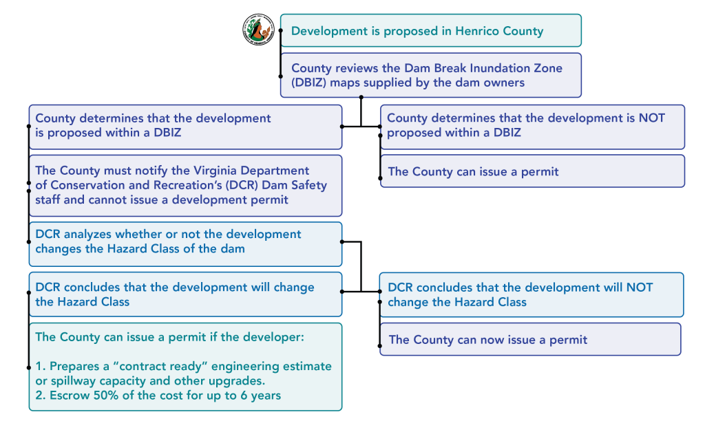
When development is proposed in Henrico County, Virginia law requires that County officials follow the steps below. Proposed developments that change the hazard classification of a dam must meet additional requirements to receive a permit. For more information about these requirements, you can also review the County Zoning Ordinance or the County Subdivision Ordinance.
Am I building in a DBIZ?
- Open the Dam Safety Map in your internet browser.
- Turn layers on or off. DBIZs are not shown by default. In the top right corner, click the button that looks like three squares stacked on one another. Check the box next to VFRIS Dam Break Inundation Zones to turn on this layer. For a simplified view, uncheck the box next to Henrico Flood Zone and Dam Safety Information to turn off flood zone information.
- Access the legend. In the top right corner, click the button with three horizontal lines. The legend will show you what the different symbols on the map indicate. DBIZs will appear as colored lines on the map. Dams are shown as white icons in blue circles.
- Find your property. Search the address or parcel number in the top left corner of the map to see if it is in a DBIZ or near a dam.